2021 Year in Review: A Look Back at Whales & Ships in the Santa Barbara Channel
This Year At A Glance
It’s been a busy year in the Santa Barbara Channel. The rich biodiverse waters between the Channel Islands and the mainland were once again a popular feeding ground for humpback, blue, fin, gray, and killer whales. It was a particularly active season for humpback whales, with over 700 reported sightings between May and December. There were also several exciting wildlife encounters including pods of killer whales in August, September, October, and December that were observed in and around the Channel Islands National Marine Sanctuary this past year.
Wildlife showreel by Adam Ernster, a Santa Barbara-based cinematographer and naturalist.
In addition to being an important feeding ground for our ocean’s giants, the Santa Barbara Channel is also a part of an international shipping route leading to and from the Ports of Los Angeles and Long Beach, one of the busiest port complexes in the world. With thousands of vessels transiting through these waters there is an elevated risk of ship collisions with whales–a risk that was even greater this past year with maritime shipping at an all-time high and an unprecedented backlog of cargo ships at major ports around the world. Here in Southern California, the traffic jam at the ports of Los Angeles and Long Beach had as many as 100 ships anchored for days and weeks at a time (Source: The Guardian).
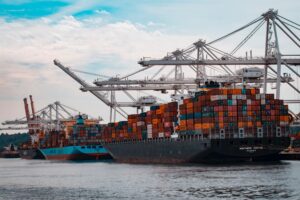
Photo Credit: Andy Li via Unsplash
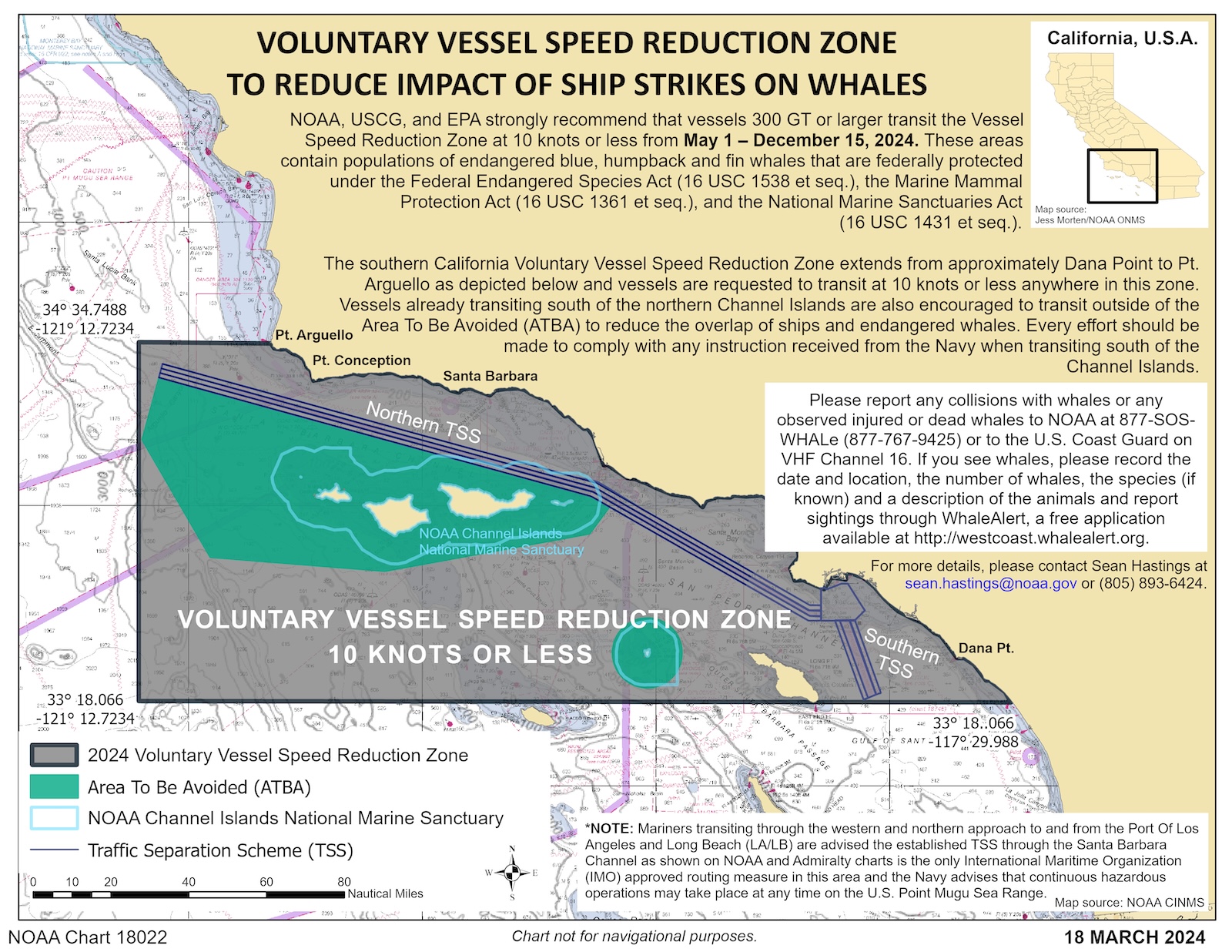
With an overall increase in maritime shipping activity, it is now more pressing than ever to continue our work on Whale Safe to reduce the risk of whale-vessel collisions. Our technology-powered mapping and analysis tool displays near real-time whale and ship data to alert ships of the presence of endangered whales and to encourage operators to slow down in the vessel speed reduction (VSR) zone. The VSR zone, implemented by NOAA, the Coast Guard, and the EPA, is a defined area with voluntary speed limits of 10 knots or less for large vessels during peak whale season to help protect endangered whales from fatal ship strikes. This past year the VSR zone was extended for an additional month due to a high number of whale sightings late in the season.
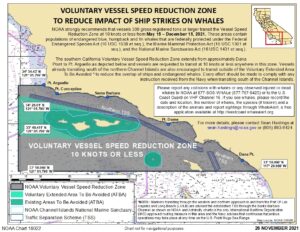
NOAA, the Coast Guard, and the EPA implemented a 10-knot voluntary speed limit for large ships transiting the region from May 15 to December 15, 2021. This notice is sent to vessels via the Coast Guard Local Notice to Mariners.
To provide alerts of whale presence throughout the VSR season, Whale Safe incorporates three types of near real-time whale data: visual sightings; a predictive blue whale habitat model, and acoustic detections from a moored acoustic buoy that is deployed out in the Santa Barbara Channel. The video below shows a daily summary of these three types of data collected by the Whale Safe system during the 2021 VSR season.
Summary of Whale Safe Data from May 15 – December 15, 2021
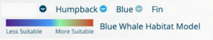
Video displays a daily summary of Whale Safe data. The underlying colors show the habitat suitability for blue whales, with warmer colors indicating more suitable habitat conditions. Whale sightings are shown with whale tail icons, and acoustic detection frequency is shown in the top right corner.
The visual sighting observations were collected by trained naturalists and guides at organizations including Channel Islands Naturalist Corps, Channel Islands National Marine Sanctuary, Island Packers, and the Condor Express. Overall, there were 723 humpback, 3 fin, and 5 blue whale sightings recorded between May 15 and December 15.
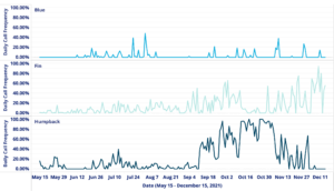
Acoustic detection data for blue, humpback, and fin whales transmitted from the moored buoy system in 15-minute summary periods. The Daily Call Frequency is the percentage of 15-minute summary periods with confirmed acoustic detections of each species each day.
We integrate these three data streams into a near-real-time whale presence rating to provide a daily assessment of whale presence in the Santa Barbara Channel to ship operators and resource managers. This whale presence rating is either classified as low, medium, high, or very high. This past year, out of the 215 days that the VSR zone was in effect, the whale presence rating was “Very High” or “High” for 214 days, underscoring the importance of adhering to the recommended speed reductions during this time.
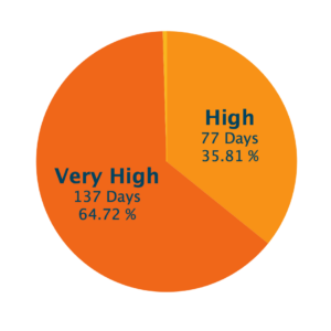
During the VSR season from May 15 to December 15, 2021, the Whale Presence Rating was consistently high or very high.
In addition to reporting on whale presence throughout the Santa Barbara Channel, we also integrate Automated Information System (AIS) data, a GPS-like tracking system on ships, into our reporting system to monitor ship traffic and understand whether operators are cooperating with these voluntary speed restrictions. Looking at the AIS data from this past year, we saw more shipping activity with both an increase in the overall number of vessels and an increase in the total nautical miles traversed through the VSR zone compared to the previous year. Overall, there were 1,159 large vessels (>300 tons) that transited a total of 714,749 nautical miles–a 23% increase in the number of ships transiting through this area and a 12.6% increase in the overall number of nautical miles traveled within this zone as compared to the previous year. Despite the overall increase in vessel activity, the cooperation rate of operators improved this year from 54.3% to 58.8%.
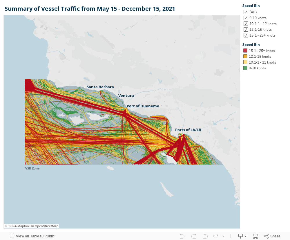
Vessel tracks within the vessel speed reduction zone from May 15 to December 15, 2021 shown according to speed: Less than 10 knots (green), 10-12 knots (yellow), 12-15 knots (orange), and more than 15 knots (red).
Milestone & Successes
With our launch in 2020, the end of 2021 marks the second year of data collected by the Whale Safe detection system. As we look back on the analytics from this past year, there are a few successes we would like to celebrate:
- Increase in Overall Cooperation Rate: Despite more vessel activity this year, the overall cooperation rate improved. Compared to 2020, the cooperation rate increased from 54% to 58% with more ships slowing down to 10 knots or less in the voluntary vessel speed reduction zone – a collaborative success with other organizations like NOAA and Channel Islands National Marine Sanctuary who have also been working on slowing vessels down in the Channel.
- Improved Grades for Specific Companies: The table below shows the top 12 shipping companies that most frequently transited the Santa Barbara Channel during the VSR season. The majority of these companies improved their cooperation scores from the previous year.
Top 12 Shipping Companies by Fleet Transit Distance for 2021
| Operator | Grade 2020 | Grade 2021 |
|---|---|---|
| MSC Mediterranean Shipping Co | A (90.1%) | A (92.8%) |
| Yang Ming Marine Transport | B (78.9%) | A (83.9%) |
| Chevron Shipping Co LLC | B (77.9%) | B (78.3%) |
| COSCO Shipping Lines Co Ltd | B (61.1%) | B (75.7%) |
| CMA CGM SA The French Line | B (69.8%) | B (71.7%) |
| Maersk A/S | C (55.4%) | B (71.7%) |
| Ocean Network Express Pte Ltd | D (29.2%) | B (66.9%) |
| Wan Hai Lines Ltd | F (17.9%) | B (65.3%) |
| APL LLC | C (58.2%) | C (57.3%) |
| Evergreen Marine Corp | C (48.2%) | C (56.4%) |
| HMM Co Ltd | F (19.0%) | D (35.9%) |
| Matson Navigation Co Inc | F (14.0%) | D (21.5%) |
This upcoming year, we will continue to build out additional ways for shipping companies to ingest Whale Safe data into their central communication and improve cooperation even further. Currently, you can sign up for daily or weekly whale data updates or monthly shipping data updates on the get involved page on the Whale Safe website, or you can access the daily whale data via our Twitter feed (@whalesafe_ca) or through an Application Programming Interface (API). Email us boi-whalesafe@ucsb.edu to find out more.
Stay tuned for some exciting Whale Safe announcements coming soon!